200 km. Cyclone Mokha may hit at speed
Cyclone Mokha is gradually gaining strength and transforming into a very intense cyclone. The storm is expected to make landfall over Chittagong, Cox’s Bazar and Myanmar’s Rakhine state at a speed of about 180 to 200 km per hour. The storm will hit the coast on Sunday morning, May 15. weather.com
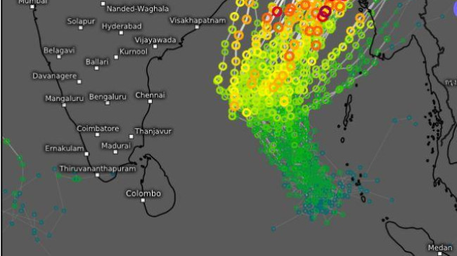
Cyclone Mokha tracks in the European Union’s Integrated Forecast System
This information is known from the 51 possible paths and wind speeds of the cyclone head found in the weather model of the European Union’s Integrated Forecast System. This picture is called ensemble weather forecast in meteorology parlance.
According to the forecast, the cyclone may lean slightly towards Myanmar or Barisal division. In that case there is some possibility of crossing over Chittagong and Noakhali districts. Similarly, it may move slightly to the right and make landfall over Cox’s Bazar and Maung Du District of Rakhine State in Myanmar.
The coastal areas of Chittagong and Cox’s Bazar are likely to be inundated by a 15 feet high tide. Coastal areas of Barisal division and coastal districts of Khulna division of 7 to 10 feet and 5 to 8 feet high tide are likely to be inundated. In particular, the storm may pass over Saint Martin Island, Teknaf, Qutubdia and Maheshkhali upazilas of Cox’s Bazar. Rohingya refugee camps in Teknaf are at risk of being affected by the storm.
Due to the storm, 250 to 400 mm of rain is expected in Chittagong and Cox’s Bazar districts, 200 to 300 mm in Barisal division and districts of Chittagong Hill Tracts.
Besides, 150 to 250 millimeters of rainfall may occur in Khulna division, 100 to 200 millimeters in Dhaka and Sylhet divisions, 50 to 100 millimeters in Rajshahi and Rangpur divisions and 100 to 150 millimeters in Mymensingh division.